Chapter 3: Pre-Revolutionary Period
1761 - 1774
The clearing of the wilderness proved too great a task for the Welsh unaided. Great tracts in this community remained untouched. Many of the younger generation sought less strenuous labor. In comparison with the Scots-Irish, the ideal pioneers of America, the Welsh were more clever and as stubborn in argument as the former were in a fight; but neither the average Welshman nor the typical North of Ireland man were born farmers.
Many of the Welsh were land poor, since the French and Indian wars had increased the taxes and at the same time encouraged the German emigrants and redemptioners to settle throughout the area, from about 1763 to the beginning of the Revolution. The German invasion of this region, like that of the Scots-Irish, apparently had its inception more on economic than religious grounds.
Many of these tracts lay some distance from the public roads, hence lane or land rights, also water rights, were freely granted. The movement resulted in two or three practically continuous German settlements in the eastern, central, and western parts of the territory extending substantially across the cultivated land.
That the Germans settled in such numbers as to seriously dispute with the Welsh the language of the community is a matter of doubt. The dream of a Welsh barony had dissipated long since and the Cymric dialect, present only in the earlier records of the religious bodies, had died with the second generation. All legal documents, gravestones, etc., were in English. The English and Scots spoke no other than English; the Welsh after the first generation understood it, and the Germans had to learn it.
Jacob Frick, of Swiss origin, arrived in America according to the family records in September of 1733 and settled first near Pottstown. About 1740 he married Elizabeth Urner who died in 1757 shortly after the birth of their youngest son, John. It is believed that the Frick family attended Coventry German Baptist Brethren Church. John was reared by Catharine (previous surname unknown) Frick, who was Jacob's second wife.
In 1769, when John was 12 years old, the family moved to a 100-acre farm located in the Chester valley of Tredyffrin township “two miles from Valley Forge,” where they lived during the Revolution, “near the scene of the Paoli massacre, and where the British and Hessian army encamped after the battle of Brandywine.” John was assigned to the Tredyffrin militia, but, as a German Baptist, he did not attend meetings and was fined.
Jacob Frick does not appear on the tax list of 1771, but he is listed for 100 acres, two horses, and two cows in 1774 and in subsequent years. The place was located at what a century later was the Abraham farm at New Centerville. John Frick reported a loss of £120 due to depradations during the British encampment in 1777.
The farm “descended” to Nathaniel and Christiana Frick Jones. Christiana was John’s half-sister, as she was the first child of Jacob Frick’s second marriage. The Jones farm was located adjacent to the Frick farm.
The early tax collectors. often illiterate, seldom recorded the occupations of the taxpayers until about a decade prior to the Revolution. Then it appeared that not only nearly all the German emigrants had some trade or another, but that there was quite a sprinkling of the second or third generation of the original settlers with occupations other than that of farmer or farm laborer. However, all or nearly all, including the preachers managed farms of greater or lesser extent.
John Davis and, later, James Currie, of Tredyffrin, are recorded as physicians; Sampson Davis kept the store at Spread Eagle in 1766 and he was followed by Richard Miles. Christian Workizer had a shop near Howell’s tavern, and Samuel Davis had a store near by, probably at Paoli.
Isaac and Anthony Wayne operated a tanyard at their farm “Waynesborough” and doubtless supplied oak and hemlock tanned cowhide to the cordwainers, or shoemakers, of the vicinity - Amos Jones, John Briggs, Daniel James, John Keck and Boston Rink. The latter took care of the custom of “Cockletown.” Morris Morris, Thomas Jones, and Thomas Williams looked after the footwear and probably the saddles and harness of Easttown.
Benjamin Robinson, followed by Mathias Woolman, were weavers of this period, soon reinforced by James Nealy (Cockletown), John Baker, Henry Ruth, Peter Stickler, Peter Stedler (Spread Eagle), Daniel and Felty Shewalter, with Christian Brannaman (“Brandyman”), Henry McQuead and John Fulton of Easttown. There were many ways of spelling the Neeley family name. which appear on these pages are an accurate representation of the many variations found in documents of the 18th and 19th centries. For example, it is spelled two different ways in the title of a 1795 court petition.
James Davis (1767) and John Dunbar (1768 - 1769) were assessed for a fulling mill, probably the same one, and William Bailey is listed as a fuller (one who bleaches or whitens wool or cloth).
There were blacksmith shops in the vicinity of the Spread Eagle, Paoli, Howell’s, and the Leopard at a very early date. Later, David, a son of William Evans, the first blacksmith at Paoli, ran a shop in addition to a hundred acre farm. Paul Sharraden (1769 - 1774) and Joel Watts , Spread Eagle, Thomas Pennington, Howell’s tavern and Morris Davis also followed the blacksmith trade. Joseph Massey, Anthony Thomas, and Thomas Watkins ran the Easttown shops.
Joshua Evans was a carpenter until he turned to tavern keeping and politics at Paoli. Humphrey Wain is listed as a “joyner”; Robert Fullerton, painter; William Pomroy, tinsman; Robert McGuigan (Easttown), butcher; Joshua Humphreys, clockmaker; Peter Mather (later taven keeper at the Warren), vendue cryer; and Benjamin Ronbinson, lemon peddler.
Perhaps there is no business more simple and lucrative than that of distilling spirits. This became clear during the first few years of the Prohibition. In the early history of the country the distillation of strong drink was one of the first industries engaged in as an honorable employment and there were many unrecorded stills for rye whiskey. One was located on the Davis farm just below Howell’s tavern, another at the “Black Swan” in the wooded ravine below Neeley’s and another just back of Neeley’s on the hillside.
The Neeley log cabin still stands on Old State road one block north of T/E Middle School and is used as a residence today.
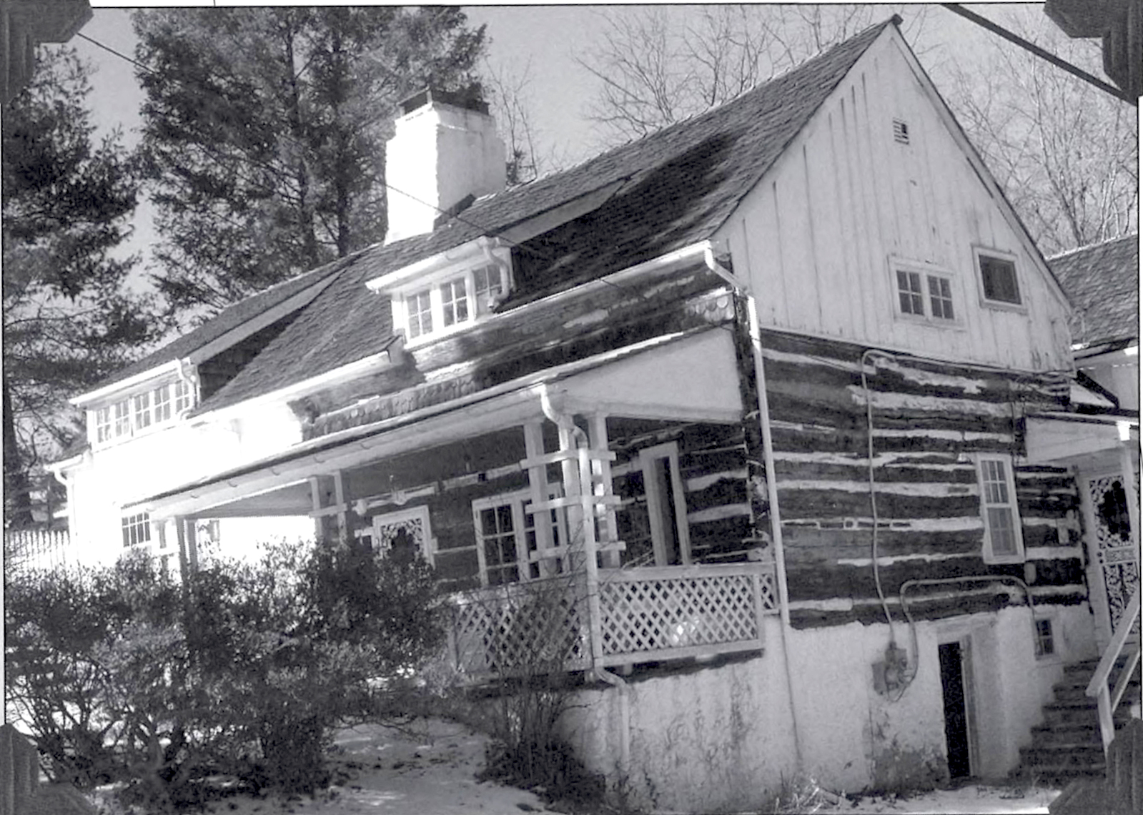
Recent view of the former Neeley log cabin. It stood at the head of a ravine on the north side of Old Cockletown. James Neeley’s deed was dated 1780 although he is said to have resided there as early as 1775. Photo by Marc J. Heppe.
Swift flowing water is needed to power a mill. Easttown has but a short stretch of the Darby creek of sufficient volume to turn a wheel, nevertheless, it had a sawmill 1768 - 1774, operated by John Morris, the emigrant, came from Merionethshire, Wales, 1708, with his wife Jean and son John. Ellis Pugh also came on the same ship and taught young John his ABC's on shipboard. John Morris' grandson, Lewis, came from Hilltown, Bucks County to Easttown in 1764 and bought land, some of which is still in this family.
Sometime during the late colonial or pre-Revolutionary period a straggling hamlet of less than a score of humble homes came to be known as Cockletown. It extended for half a mile or more along the Lancaster, later known as the Conestoga or Old road; from a short distance in Easttown east of the Fox tavern (Francis avenue), to a little beyond Peggy’s corner (Howellville road) in Tredyffrin; and flourished up to the Turnpike era.
Although situated on the first and chief inland highway of the province, it was somewhat isolated locally. The nearest crossroads, the Welsh Line or Baptist road, was a mile to the east and the Bear road a mile and a half to the west.
There then existed, however, a private wood road or right of way, through the Atkinson, later John Reese land, leading down to the valley and on out to the Swedesford road (today’s Circuit City store) near Wilson’s Corner.
Another bypath began at Peggy’s Corner, which gave access to the Neilley’s and continued down the wooded ravine to the Black Swan distillery and beyond through the Reese plantation, with several gates, to the Swedesford road opposite the present entrance to Chesterbrook.
A third ancient lane, a quarter of a mile west of Peggy’s Corner, entered deeply in the hills and turned to a dead end in Prissy’s bottom (where today’s Bodine road turns uphill to the south), giving access to the residents of some five or six log houses on the southern exposure of the hills; but this right of way extended no further, except by footpath, to Howell’s Tavern, now Howellville.
Scarcely more than a hundred yards north of the Old road at any point and sometimes bordering it, was an almost unbroken forest of deciduous timber, with here and there a stand of pitch pine, and frequently a dense border of red cedar. The hills and ravines of the Slate ridge, or South Valley hills, had also a dense under growth of laurel and wild grape vine; the small bogs or swamps an almost impenetrable mass of spicewood and green-brier.
The dwellings of this early settlement at Cockletown, perhaps the earliest incipient town of Easttown, were mostly of the log cabin type, built of oak or chestnut logs, with stone chimneys; occasionally one more pretentious had stout stone gable ends. However, they were mostly small and homely, erected so close to the right of way that the habitants could step from the doorsill directly into the road. On one side was the wood pile and the well with its windlass and oaken bucket; on the other the lye barrel, the lilac bush, the clump of hollyhocks, and more than likely the pig pen.
Few of these squatters, tenants or small land owners kept a horse; but few were without a cow, at least two hogs, and a flock of poultry.
The cleared plots were not extensive, though ample to grow enough corn, potatoes, cabbage, turnips, and
pumpkins to carry the stock and family over the winter. They planted five grains of corn to the hill, according to the proverb:
One for the blackbird one for the crow;
one to rot, and two to grow.
However remote from town, Cockletown was by no means lonely. Until about 1730 the Old road had been almost exclusively a packhorse trail, as it had been more anciently an Indian path. Later it became a thoroughfare fifty feet wide for traders, emigrants, drovers, freighters in Conestoga wagons, etc., deep in mire or dust, according to the season or state of the weather, and the small homesteader could no longer plant his corn in the middle of the road and require the occasional traveler to detour as best he could.
This hamlet, was only locally known at Cockletown, but whether given in honor of the alleged ancient Welsh national flower, the corn cockle, as some say, or in disrespect by the more prosperous farmers, who centrainly regarded the hill clearings as “fit only for growing timber and weeds,” is an open question.
In the Burn family papers there is the statement of Eizabeth Burn, nee Jones, who was born in 1797, four miles east of this place and an actual resident here from 1832 to 1879. She asserted that this place was called Cockletown and that the name was derived from the cornflower, an imported European weeed closely related to the ragged robin, which flourished and became very troublesome in the wheat fields.
The settlers at first had no other means of lighting their cabins than that furnished by the open fireplace, but after awhile they became more affluent and tallow dips came in fashion.
Well dressed, notched and chinked log dwellings, though snug and warm, had one great fault. The American bug indigenous to the inner bark of the ancient hemlock, frequently transferred to the log cabin and was difficult to eradicate. This condition of affairs gave expression to a none too polite or delicate saying:
Good night! Sleep tight! Don’t let the bugs bite!
Proceeding westward on the Old Lancaster road in Easttown, there were two small log houses on the north side, one in front of where Westley Jones, shoemaker, built his new frame house in 1862, and the other close to the entrance to the late Dr. Okie’s place. On the south side there was at least one, possibly two, log dwellings.
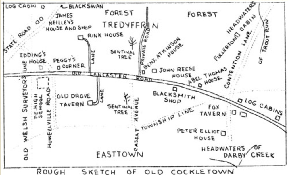
Plan from Chronicles of Old Cockletown by Franklin L. Burns
This land was a small part of the 2000 acre tract patented by William Wood and William Sharlow, surveyed August 21,1684, and in the sub-division of l000 acres of the latter, November 28, 1704. The entire tract then came into the possession of Richard Harrison, and later, September 11, 1746, Samuel Harrison, and 119 acres, later to Standish Ford.
Then came the Fox tavern, the only building entirely of stone. Its erection is of unknown date. Historian Julius Sachse informs us that it was kept by Fox from 1792 to 1797, and by David Llewellyn until 1804, when it ceased to be a place of public entertainment and became a country store.
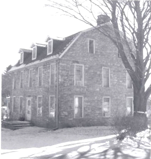
The Fox tavern located on the Old Conestoga road in Easttown was kept by Henry Fox until the Lancaster turnpike opened in 1798 and diverted most traffic south to the new road. This contemporary view shows the building today as it was greatly renovated about 1900 by the Joseph Williams family.
Its site marked the extreme northeastern corner of the l000 acre “Travelgwyn” tract of William Wood. The northern quarter section of 250 acres came into the possession of ten persons in succession, the last being Peter Elliot, April 15, 1723.
The old tavern was demolished about 1900 by the late Joseph Williams family to make way for a more modern dwelling. Old English coins have been found while digging in the vicinity, probably relics of the pitch-penny period.
The next tract on the south side of the road is also mostly in Easttown and early belonged to Peter Elliot who was a blacksmith.
The early Tredyffrin ownership of the land on which Cockletown was situated, appears less complicated than that of the Easttown end. William Standly patented 300 acres between the two Welsh lines, Baptist road and the Welsh line near Peggy’s Corner. This was a strip immediately north of the Easttown line. Its entire acreage was acquired by John Day and passed to his widow Hannah (her second husband was James Atkinson) and then to Grace Peadwell, Hannah’s daughter. Thomas Godfrey owned it in 1749. The latter or his son disposed of the aforesaid tract in smaller parcels and all of the western part is included in the ancient hamlet of Cockletown.
On the north side of the Old road there was a stone and log dwelling about where Dr. Wharton’s house stood, but closer to the road. This may have been built by Abel Thomas, carpenter, who owned about 70 acres in the vicinity, mostly in the woods, in 1783. This house was later occupied by Widow Jane Dane after she had retired from the Springhouse Tavern.
A short distance west and on the opposite side of the road there was a blacksmith shop The site was probably immediately in front of the cottage built much later by Levering Latch, where scrap iron and a cannon ball were unearthed. The late Mrs. Benjamin Longaker, nee Lewis, has said that she remembered this building from her early girlhood when it was in a tumbledown condition. It had the appearance even then of being very ancient and was reputed haunted-lights appearing in the windows as if the ghost of the blacksmith had returned and was busied relighting the forge.
The John Reese house, later the residence of the Rev. Dr. Sagebeer, doubtless dates from the Reese ownership. This, of logs, is now weather-boarded. The low, long barn dated from 1830 and was removed about 1880.
Abel Reese in his will, January 8, 1797, bequeathed to his son John, his plantation of 63 acres, he to pay his sisters Judith and Elizabeth, £100. The first house on this farm, was a small one of logs close to the public road, on the extreme southwest corner of that position of land north of the Old road and close to the entrance of the wood road to the valley. It was probably built by John Thomas or earlier, in Atkinson’s time. This building was removed about 1876.
The original Drove Tavern (or taverns, since the story goes that there were two connected by an underground passage) was on the site of the later Fritz house, and was reached from the Old Lancaster road by a lane. In 1779 it was said to be kept by Thomas Search; certainly, either this or the last Drove on the Turnpike was kept by John Reese and his son Abel.
On the North side of the Old road and west of the John Reese farm, was the Burns farm, as it became known. Thomas Godfrey parceled out the Standly grant in smaller lots as before mentioned; forty acres to Thomas McKean and thirty acres to John Shaw in 1750. Shaw sold to Enoch James, James transferred the same to Christian Brannaman, usually listed as “Brandy man,” and the executors of the latter to Sebastian Rink. McKean also sold to Rink.
McKean was landlord at the Blue Ball Tavern and was taxed in Easttown for 400 acres of land. He was the largest landowner there in 1765. Heretofore we have had Welsh, Scots-Irish and English owners, but Brannaman and Rink were Germans. A marker was erected by the D.A.R. over the grave at St. Peter’s of Ensign George King, who is said to have been a younger son of a German baron. He married in 1756, Catherine, daughter of Christian Brannaman.
Rink was a shoemaker. The records show that he did not come in absolute possession of the eastern tract of 30 acres until 1765 and the western tract of 40 acres until 1769, though he was probably in residence earlier. His first assessment was erroneously from Easttown. His residence on the western tract not far from the only available spring would seem to indicate an agreement for its purchase, and it was he who replaced the original log cabin with a mansion (in those days) of thick stone gable walls and dressed log front and rear, and caused to be traced deeply in the wet mortar of a countersunk square high up in the west gable “B.R. 1767”.
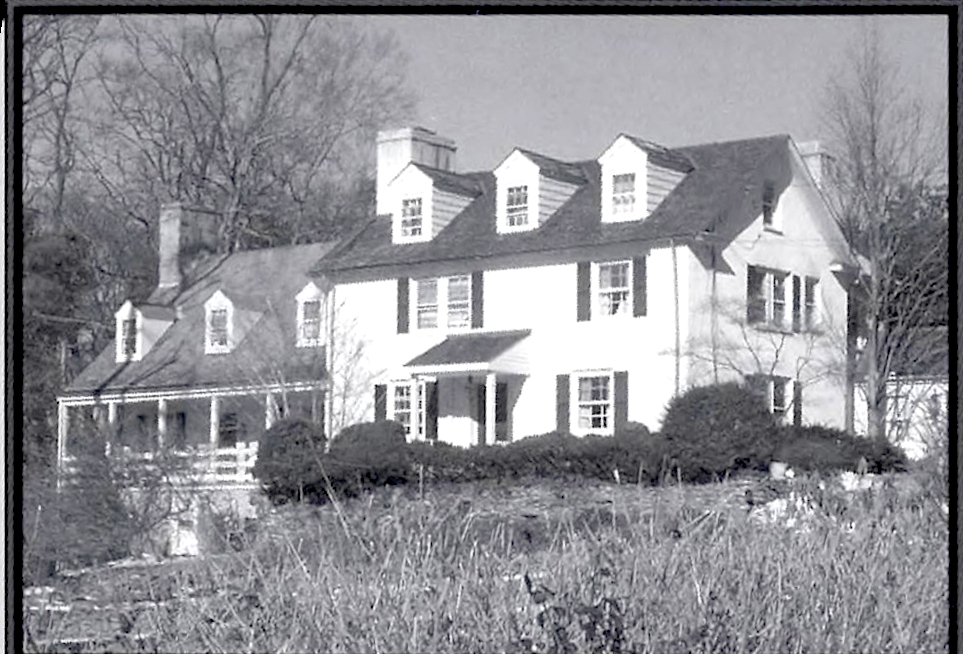
Sebastian “Baastin” Rink, of German descent is credited with building the stone house which is tucked away on a hillside north of Old Cockletown. It was later the Peter Burns farmhoue and still later the residence of George P. Orr. The old section of the house is on the left. Photo by Marc J. Heppe.
In 1775, after the sale to Christopher Rue, Rink disappeared. This was not an uncommon subterfuge, during the Revolution to prevent confiscation should the Crown prevail. Rue, who was a lieutenant of the Easttown militia, conveyed the property to Andrew Steel of the Leopard Tavern, in 1779, two years after Steel, a non-combatant had conveyed it to Joseph Griffith, an officer in the Tredyffrin militia. Both officers filed lists of damages inflicted by the British army, aggregating 67 pounds, 2 shillings and 3 pence. The house was later the residence of George P. Orr, who greatly enlarged and remodeled it.
The next habitation was immediately in front of the Robert Doyle residence, long known as Peggy’s Corner, an ancient log cote which Dr. Quimby immortalized in his novel “Valley Forge” as “Peggy Hambleton’s Cake and Beer Shop.” Old English coins have been excavated here. Later the site was only a heap of stones at the foot of an ancient cedar. It was replaced by the present small house on the southeast corner of Howellville and State roads in 1846.
The last house on the Old road in Cockletown was near the former MacNamee house later occupied by S. Paul Teamer. It was a long, low structure of logs and of two periods: the easternmost section very old; the western end built later where a tenant at one time kept a night school. It was called “Corner Lott” in the 1792 will of old Abel Reese when bequeathed to wife Violetta. This tract was mainly west of the old Welsh line which ran from the Newtown Street road through Easttown. A very early owner was Richard Iddings whose daughter Elizabeth was the mother of General Anthony Wayne.
Not all of the houses of Cockletown lay close to the Old road; several were hidden in the folds of the wooded ravines leading down to the valley. In “Lewis’ Hollow”, then reached by a wood road through the Reese land, there was a tract of ten acres. The original log house was embedded in the southern slope of the hill near the upper spring.
“Neilley’s Hollow” also contained inhabitants. There was a small log cabin on the crest of the hill above the springs (in the midst of Doyle’s North Berwyn nursery). This probably belonged to the Reese family at one time. Tradition states its early tenants operated a small distillery at the source of Trout Run immediately below, probably the Black Swan.
Of the two or three original Cockletown houses now standing, the Neilley house is the oldest. The homestead of one or more acres is said to have been part of an original grant of 100 acres to Thomas and Cadwalader Jones by right of their mother. James Neilley, according to family history, was born in 1750 in the County Antrim, Ireland, came to America in 1768, and set up a handloom for linen weaving in 1775.
This house was built of stone on the living rock, the rear buried in the side of the hill; the superstructure of logs and the original bowed roof was thatched with rye straw. It had one room in the basement, two on the first floor and an unceiled garret. The shop for weaving was an abandoned stable one and a half stories high, with earthen floor and no provision for heating. It stood immediately in front of the house and was demolished about 1880, and a small one-story annex added to the west side of the cottage, which served for a carpet weaving loom for the last Neilley, also a James. In the renovation of this old house, William Doyle was careful to retain all the outward features, so that while the interior was made comfortable, the exterior presents much of the characteristics of by gone days.
Thus did Cockletown, without plan or forethought, come into existence. It was just a typical community of its time, composed mainly of mechanics and small farmers combined, but an essential part of the rural economy of a growing colony.
Doubtless its inhabitants had front row seats for the series of important military events which took place in the neighborhood beginning in the early autumn of 1777. But with the completion of the Turnpike in 1798, Cockletown became just another backwoods settlement and passed into harmless disuse long before the Reeses erected their sign “Reeseville” opposite the Drove Tavern.
At The Same Time
Mason-Dixon line established between Maryland and Pennsylvania
Russia and Turkey at war
Captain Cook, English navigator, discovers east coast of Australia
Boston Massacre; British troops fire on mob in Boston; five citizens killed