Chapter 1: In the Beginning
1681 - 1704
On September 15th, 1681 some Welshmen of means purchased 40,000 or 50,000 acres from William Penn (commonly known as the “Welsh Tract”).
It was to have been in land lying contiguous, subject to local government of the Welsh Friends to whom the land was apportioned.
It included Haverford, Merion, Radnor, Tredyffrin, and subsequently the greater part of Newtown, Goshen, and Uwchland townships, for Penn was unable to redeem all of his promises of a separate colony or Welsh “barony.” This caused great dissatisfaction, especially after the division of counties cut the Welsh Quaker settlements in two, and they found themselves in a minority. Politically it probably kept some very able men out of office, but gave the death blow to a clan of citizens perpetuating a dialect, for the Welsh had dwelt for ages in proximity to the Englsh and yet preserved their own peculiar language, a language that was forgotten in America in less than three generations.
Wales was not and never had been a rich country. The people were poor, proud, and found it difficult to forgive a slight upon their dignity, but there are degrees of poverty, for some were not so poor that they were under the necessity of engaging in business, the so-called landed gentry. Yet they held that a man might follow any honorable calling or trade and remain a gentleman.
The prime motive that induced the Welshman to give up the impoverished land was to better his condition economically. Wales, too, was in the midst of religious dissentions and many non-conformists suffered persecution from the Established Church and longed to be free of religious conflicts.
Penn’s terms were liberal, 100 pounds sterling for 5000 acres, subject to a quit rent of one shilling for every 100 acres, payable upon the first day of March, forever; which last clause became a dead letter following the Revolution. Many were content to purchase 500 acres or less, and the more affluent were attended by numerous kinsmen, ostensibly as servants, anxious to partake in Penn’s bounty of 50 acres for each, and his guarantee of religious freedom.
Thus the early Welshmen flocked to the western shore of the Delaware. A sturdy, worthy people, more clannish and old fashioned than the English, Dutch, and Swedes who had proceeded them here, but they were the best in Wales. The women in tall beaver hats and outlandish cloaks, were good wives and mothers. They came to brighten up the waste places in the New World. Their fate, however, was not only to toil from sunrise to sunset, but by candle or fire light at night, and their joy to add the feminine touch to the home, to plant the flower garden in the few moments of leisure, and to initiate the young in the rudiments of book knowledge, often with the Bible as the only text book.
Like all other races, the Welsh brought with them all the prejudice of the old country, and the petty differences of creed continued to separate neighbors. Settlers living convenient to a meeting house not of their own persuasion underwent considerable hardship over the rough roads to the house of their own peculiar denomonation.
Although not included in the Welsh “barony,” Easttown did have 1000 acres surveyed to Welsh settlers by its First Purchasers. Easttown originally was entirely in the possession of three English land speculators. Interestingly, the Easttown Welsh were Church of England men, not Quakers.
William Wood and William Sharlow, the latter a prosperous London merchant, appear to have been the so called “First Purchasers” of part of northern Easttown. James Claypoole, a friend of Penn’s, a member of the Free Society of Traders and the first prothonotary of Philadelphia, received a grant for a block of 1050 acres extending across the southwestern part. These men were non-residents of Easttown although it is possible that Claypoole had someone is his employ clear off some ground near the present location of Leopard. Newtown “Street” was laid out north from Newtown to near the Easttown border in 1683.
{See the Easttown deed history here, which contradicts some of the statements in this section.}
The Welsh tract in Easttown made up less than 20% of the total township land. It was bounded on the west by the line of Newtown Street road north to what is today the Tredyffrin line. The eastern boundary passed from the corner of today’s Conestoga and Berwyn Baptist roads south across Lancaster avenue and down the little valley of the branch of Darby creek through the western part of Devon back to the border of Newtown. When in 1691 a deed was made by an heir of William Wood to Howell James for “a tract containing 500 acres on the upper end of Newtown,” a preliminary step had been taken in the history of Easttown.
“East Town” as it was originally written, was so called from its position in the county. Settlement was not spurred by any outstanding resources, waterways, mineral assets or unusually fertile soil. Locations of early saw mills indicate that some of its terrain was covered with forests. A natural feature influencing the land was the many meandering tributaries of Darby creek.
The date assigned to formation of Easttown is 1704. It is first mentioned on the court records by the appointment of William Thomas as its constable, on December 27, 1704. The resident land owners in 1715 were Edward, Ellis, Owen and Morgan Hugh, Philip and John David, David Davis and John Harris, Hugh Jones, Evan Thomas, Richard Evans, and Thomas Edwards, all from Wales and nearly all Friends or Episcopalians. There were 21 taxable settlers in 1730, 25 in 1740, 39 in 1750, and 51 in 1760.
Tradition informs us that a blockhouse for defense against the Indians was erected on an Indian clearing in the northwest angle of Sugartown and Newtown roads, just south of Berwyn, and that the first religious services, some 15 or 20 years before St. David's Church was built, were held there. This clearing was also used by the early settlers as a burial ground.
The first known settlement on land in Easttown took place between 1703 and 1706 at what became known as Travelgwyn. The exact meaning or significance of the name is obscure, but it can be translated as "white toil or trouble." The most ancient deed to the Travelgwyn estate was in Welsh, which had to be produced and translated before the Ivesters could complete a more recent sale.
This tract is just south of Berwyn, on either side of Waterloo avenue and near the foot of Waters’ Hill, and is described in a lengthy deed dated December 4, 1706.
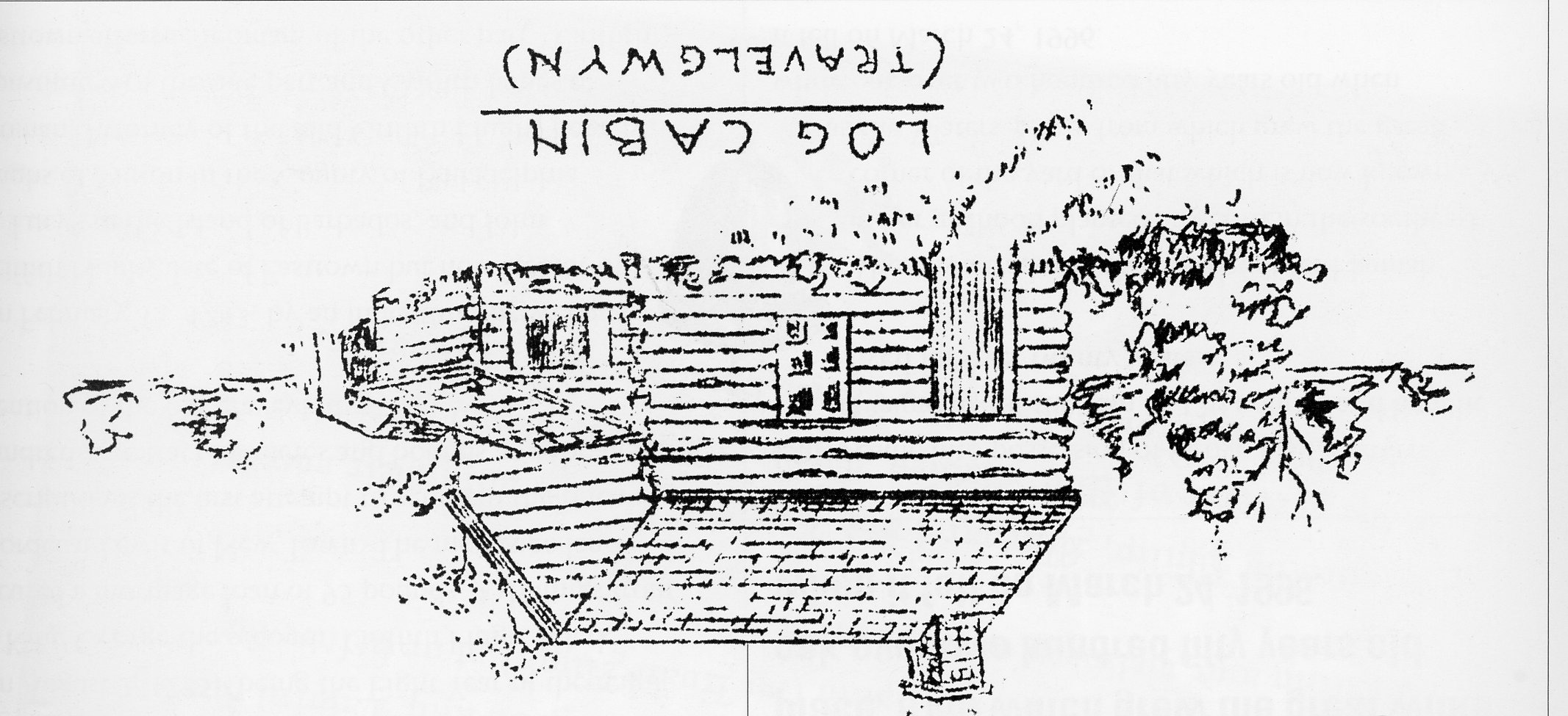
The tract contained the original log cabin which has been described as a single-storied structure with double-pitched roof, one window and the door in front and a single window in the rear. It was possibly of two rooms, had a large open fireplace, and was situated east of the present stone farmhouse and near to a spring of water on the old Ivester farm, the cabin being last used as a chicken house. At this period Trav-el-gwyn was mostly in timber, the swamp a covert for woodcock, and the branch of the Darby creek swarmed with speckled trout. It was passed on in the family fifteen years later.
The foregoing owners were closely connected, Edward Hughs being a brother to Philip Davies’ wife and Evan Hughs a nephew of the last and son of Edward Hughs, former owner. Philip Davies evidently built the stone house sometime between 1706 and 1722.
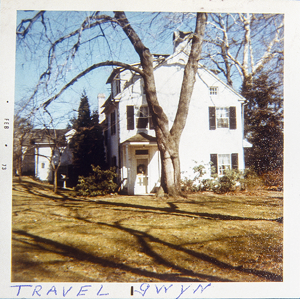
View of Travelgwyn mansion, looking east, as it appeared in February of 1973. Since that time, the stucco has been removed exposing the original brown stone. During the quarter of the twentieth centure, the house was owned by Mr. and Mrs. Maxey (Tom and Anne). Photo by Dorothy Reed. The id of the image is HOU231.
On February 20, 1723, this estate was sold by Evan and Ann Hughes, of Easttown, to Griffith Hughes, clerk of Radnor, for 140 pounds. Here it is called Grove Hall, formerly Travelgwyn. The deed was signed by Evan Hughes and the mark of his wife Ann.
The Rev. Griffith Hughes graduated from Oxford in 1732, and was appointed rector of Radnor and Perkiomen (St. David’s and St. James’ Episcopal Churches), but here we find that he was in Radnor and Easttown at least ten years earlier as a clerk and doubtless a student under Rev. Weyman and Rev. Backhouse at St. David’s.
On August 2, 1735, “being the Eight Year of the reign of King George the second,” Griffith Hugh, Clerk, secured a mortgage loan of 95 pounds, 4 shillings from Mordecai Lewis of New Town. The mortgage land description is the first attempt to set forth the one hundred-acre tract by metes and bounds and the first mention of the old graveyard.
On February 13, 1743, by an indenture “Between Griffith Hughs, late of Easttown but now Rector of St. Lucy’s in the Island of Barbados, and John Hughs of Mirion in the County of Philadelphia, Yeoman, Attorney of the said Griffith Hughs Legally Constituted of the one part and Griffith James of Easttown afforsd, Yeoman, of the other part,” Griffith James came into possession of Grove Hall, or Travelgwyn, for the sum of 120 pounds and here he lived for over twenty years.
There is a tradition that his daughter Hannah in her girlhood planted an acorn in the southeast corner of the yard of that which is now known as the Waters’ place, from which grew the great white oak over two hundred fifty years old when it fell on March 24, 1996.
When Griffith James died he left a will dated August 24, 1764 which transferred the property to his wife Ann.
Ann James died October 27, 1773 leaving daughter Hannah sole heir of Grove Hall. Hannah married Whitehead Wetherby a son of Benjamin Wetherby, who was brother-in-law of Dr. Barnado Van Leer of Marple and one time innkeeper at the old Blue Ball Tavern on the Conestoga road.
There was little excitement or romance in the settlement of Easttown for the Indians were few and peaceable. Early in Colonial times the native families were settled upon small reservations: the Okehockings on about 500 acres in lower Willistown along the Ridley creek, another along the Brandywine; reservations that were respected but a little while by the white man. Indeed the Indian left so slight an impression upon our township that not a single native geographical name is in use today.
Both Penn and the early colonists have left some account of the so-called “Indian clearings” and the mulberry and peach trees growing thereon. However, not all are satisfied that these orchards originated with the Indians. While the red mulberry is a native of America, the peach is said to have been indigenous in Persia. It is possible that these orchards were planted with seed brought over by some of the earlier Swedish or Dutch fur traders.
While there was little need of fighting men in the early settlements, there was a great demand for able-bodied men skilled in swinging the ax and in clearing the ground. Penn recommended clearing 15 acres the first year and building a log house 18 x 30 feet, with a partition through the middle and another to divide one end in two smaller rooms, and with a loft over all with a floor of clapboards, and the ground floor of earth.
The forest, mostly deciduous, with more or less pine on the hills, was a century or more old. As it had been long the custom of the Indians to fire the fallen leaves and brush to facilitate the hunting of game, it was usually free of undergrowth and open enough to drive a horse and a light cart in many places.
The Old Lancaster (Conestoga) road, or the King’s highway as it was officially known, followed more or less faithfully an old Indian trail to the mouth of the Schuylkill, for the natives in traversing the backbone of the watershed between the Schuylkill and Delaware, followed the ridge, the path of least resistance. It was the first road, and is said to have been surveyed in 1700 from Philadelphia to the Susquehanna near the mouth of the Conestoga creek, though it was not completed until 1741.
The Provincial Council took the necessary action May 27, 1718, to lay out a road from the Brandywine to the Conestoga. On November 23, 1721, relative to dispute in parallel roads: “It is Ordered that the Road now and heretofore used leading from Philadelphia to Conestogoe, through the Townships of Meirion and Radnor, and laid out by the authority of this Government as far as Thomas Moore’s Mill (Downingtown) on the Brandy Wine River or Creek, be deemed the King’s Highway and public Road.”
They spelled road in those days with a capital “R”, but apparently the exact lines were still a matter of doubt or dispute, since on October 4, 1733, the commissioners appointed January 29, 1730/31 to lay out the road to Lancaster made report that they found it inadvisable to discover where it had been altered while the corn crop was growing, and it continued in an unsettled state until July 20, 1741, when a survey over the entire route was submitted and approved by Council.
It included the more than four miles through Tredyffrin and 292 feet in “East Town”, from the Willistown line to the upper line of Radnor, with 23 angles, and mentions the “Sign of the Ball,” or Blue Ball tavern.
Gulf road was a line of communication as early as 1690, though not officially laid out until 1748, and the Swedesford, in the valley, and the Darby, Newtown, and Sugartown roads were in place in 1700 substantially as today.
At The Same Time
Siege of Vienna by Turkish Forces
Czar Peter I (Peter the Great) modernizes Russia
English monarchs grapple with religious toleration
Salem witchcraft trials in New England