|
||||||||||||||||||||||||||||||||||||||||||||||||||||||||||||||||||||||||||||||||||||||||||||||||||||||||||||||||||||||||||||||||||||||||||||||||||||||||||||||||||||||||||||||||||||||||||||||||||||||||||||||||||||||||||||||||||||||||||||||||||||||||||||||||||||||||||||||||||||||||||||||||||||||||||||||||||||||||||||||||||||||||||||||||||||||||||||||||||||||||||||||||||||||||||||||||||||||||||||||||
|
Mines Menu:
Mines Reports:
Mines Map
Use the links at the left to return.
|
||||||||||||||||||||||||||||||||||||||||||||||||||||||||||||||||||||||||||||||||||||||||||||||||||||||||||||||||||||||||||||||||||||||||||||||||||||||||||||||||||||||||||||||||||||||||||||||||||||||||||||||||||||||||||||||||||||||||||||||||||||||||||||||||||||||||||||||||||||||||||||||||||||||||||||||||||||||||||||||||||||||||||||||||||||||||||||||||||||||||||||||||||||||||||||||||||||||||||||||||
Mine Descriptions |
||||||||||||||||||||||||||||||||||||||||||||||||||||||||||||||||||||||||||||||||||||||||||||||||||||||||||||||||||||||||||||||||||||||||||||||||||||||||||||||||||||||||||||||||||||||||||||||||||||||||||||||||||||||||||||||||||||||||||||||||||||||||||||||||||||||||||||||||||||||||||||||||||||||||||||||||||||||||||||||||||||||||||||||||||||||||||||||||||||||||||||||||||||||||||||||||||||||||||||||||
Pima Mining District | ||||||||||||||||||||||||||||||||||||||||||||||||||||||||||||||||||||||||||||||||||||||||||||||||||||||||||||||||||||||||||||||||||||||||||||||||||||||||||||||||||||||||||||||||||||||||||||||||||||||||||||||||||||||||||||||||||||||||||||||||||||||||||||||||||||||||||||||||||||||||||||||||||||||||||||||||||||||||||||||||||||||||||||||||||||||||||||||||||||||||||||||||||||||||||||||||||||||||||||||||
|
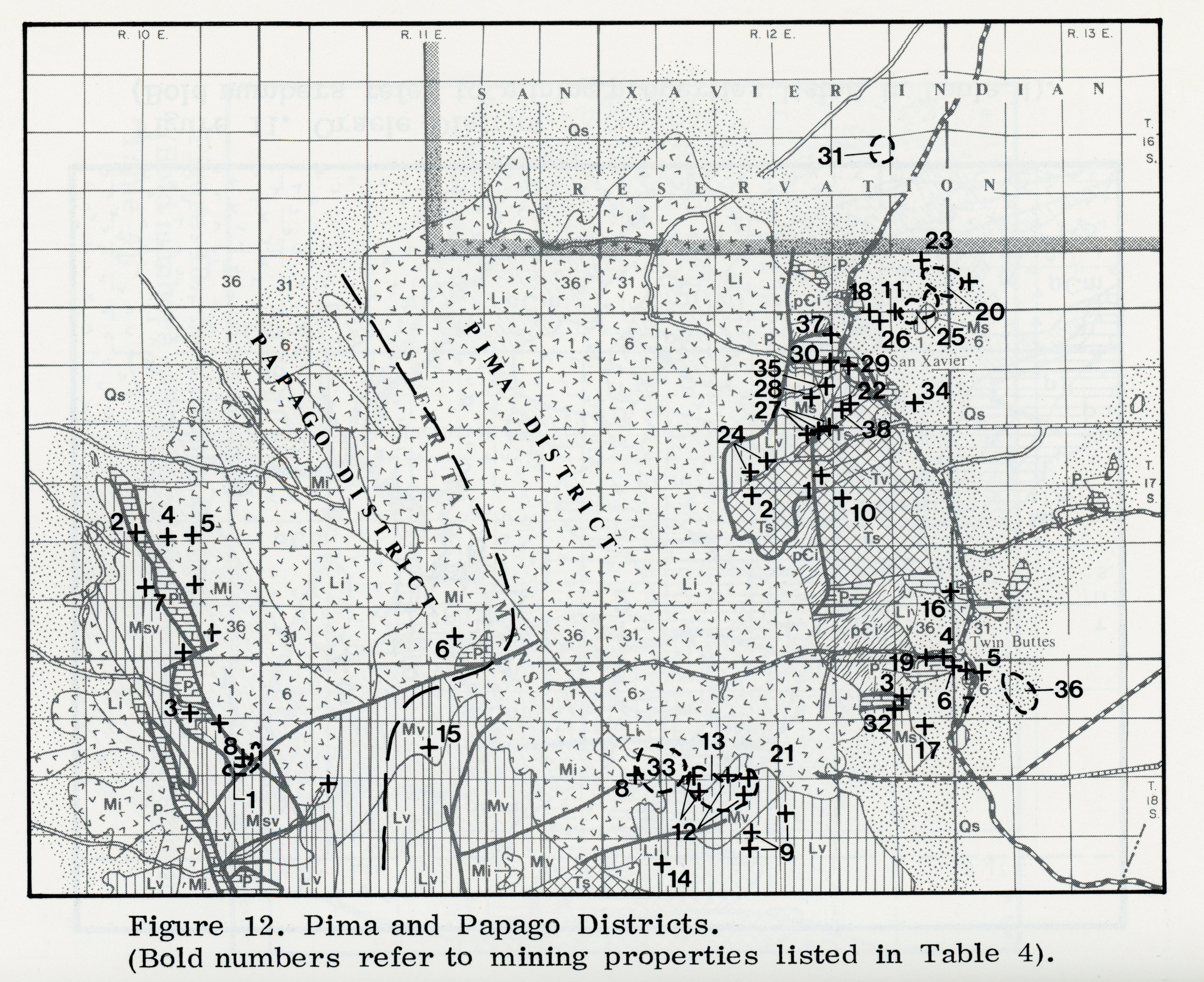
A Cu-Pb-Zn-Ag-Au-Mo-W mining area located in T.16-18S., R.11-13E., on the eastern margin of the Sierrita Mountains, from 18 to 30 road miles SSW of Tucson. As generally considered, it comprises the Mineral Hill, San Xavier, Olive Camp, and Twin Buttes areas, although the US. Minerals Yearbooks include with it the Papago and other districts of the Sierrita Mountains. A pediment slopes gently eastward towards the Santa Cruz Valley from the foot of the Sierrita Mountains. This pediment ranges in altitude from approximately 4,500 feet on the west to 3,300 feet on the east. Rising prominently above it are scattered hills, such as the Twin Buttes, Helmet Peak, and Mineral Hill. Numerous eastward-flowing arroyos carry the runoff towards the Santa Cruz River. Topography is shown on the Twin Buttes quadrangle sheet. Because of faulting, igneous intrusion, and alluvial cover, few if any of the sedimentary rock units are exposed in their original entire thickness. Over much of the area structural relations are obscure, and many features of the igneous bodies are not revealed. The ore deposits in this district include contact, replacement, and vein types. These types are somewhat related to one another. Available evidence suggests that the ore solutions ascended through fissures of northeast to eastward strike. The principal mines are less than a mile from the granite outcrop. The contact zone, nearest the granitic intrusive, is characterized by garnet and other ferric iron minerals; next outward is a zone containing ferrous iron, marked by hedenbergite; and farther outward, sulphides occur associated with little or no contact minerals (Mayuga). Mineralization is varied: (1) Small, shallow-seated, low temperature fissure veins with spotty, partly oxidized base metal sulfides and relatively rich gold and silver values, in faults and fractures in Cretaceous sedimentary formations and andesite intrusives within the San Xavier thrust sheet; (2) Pyrometasomatic deposits with copper and/or lead-zinc mineralization in silicified Paleozoic limestone, often associated with fault contacts and bordering Laramide intrusions; and, (3) Large, irregular disseminated copper orebodies with minor or considerable molybdenite and locally minor sphalerite and galena in pyrometamorphosed sedimentary and volcanic formations or in complex intrusives. The contact deposits are limestone replacements which are characterized by association with garnet, epidote, wollastonite and other silicates. These minerals occur somewhat erratically distributed in masses along fissures of various trends. In places they appear to be genetically connected with fissures of NE to eastward strike. Fissure deposits containing Pb-Ag-Zn occur in arkosic or volcanic rocks of the Olive Camp area. Some gold-pyrite veins are found n quartzite breccia of the Alpha group area. Quartz-scheelite veins occur in arkosic beds of the Senator Morgan mine area. In general the veins trend northeasterly to N.8°W. and dip steeply. Workings include numerous small to large underground mines and prospects, and large open pit operations. Total estimated and reported production up through 1972 (now greatly outdated), would be some 369,707,400 tons of ore containing 2,100,000 tons of copper, 42,000 tons of lead, 116,000 tons of zinc, 31,000,000 oz. of silver, 53,700 oz. of gold and 33,000 tons of molybdenum.3
LocationWest side, I-19 Mineral ProductsCu, Ag, Pb, Zn, Mo Geology1. Small, shallow-seated, low temperature fissure veins with spotty, partly oxidized, base metal sulfides and relatively rich gold and silver values, in faults and fractures in Cretaceous sedimentary formations and andesite intrusions within the San Xavier thrust sheet. 2. Pyrometasomatic deposits with copper and/or lead-zinc mineralization in silicified Paleozoic limestone, often associated with fault contacts and bordering Laramide intrusions. 3. Large irregular disseminated copper orebodies with minor or considerable molybdenite and locally minor sphalerite and galena in pyorometamorphized sedimentary and volcanic formationsor in complex intrusions7. Some Geologic Features of the Pima Mining District, Pima County, AZ Types of Operations and ProductionNumerous small to large underground mines and prospects, and large open pit operations. Total estimated and reported production, up through 1972, would be some 369,707,400 tons of ore containing 2.1 million tons of copper, 42 thousand tons of lead, 116 thousands tons of zinc, 31 million ounces of silver, 53.7 thousand ounces of gold and 33 thousand tons of molybdenum7. Mine Tales: Pima Mining district grew from humble beginnings by William AscarzaLocated 18 miles south of Tucson near the Sierrita Mountains and organized in 1877, the Pima Mining District had humble beginnings with several small mining camps. Deposits of copper, silver, lead, zinc and later molybdenum drew an interest to the area, including early operations conducted by the Emperor Copper Co. (1883), the Azurite Copper and Gold Co. (1897), Twin Buttes Mining and Smelting Co. (1903), Mineral Hill Consolidated Co. (1906) and ASARCO (1915). Originally worked by the Spanish for gold and silver in the 18th century, the remains of arrastras and shallow shafts were evident during early American development. Several noteworthy operations established in the district included the Mineral Hill, San Xavier and Twin Buttes mines. Early on, ores were treated at sites including a local smelter with a 30-ton daily capacity. The smelter operated for a year followed by other short-lived smelters, including a 150-ton smelter built by the Pioneer Smelting Co., a mile-and-a-half west of Sahuarita at Camp Corwin in 1912. 5 Shipments of concentrates from later mills established around Sahuarita were also sent to smelters at Hayden, El Paso and, briefly, Sasco. Several small camps operated in the area, including one named Azurite, another called San Xavier, later changed to Olive for a nearby mine, and Twin Buttes. Azurite, located a half-mile south of the Mineral Hill Mine, reached a population of 125 by the turn of the century. The high-grade lead-silver ores acquired from the San Xavier Mine before 1900 made it an attractive investment, having yielded a value of around $750,000. Four miles farther south was the Twin Buttes Camp that included a cluster of buildings housing a bunkhouse, a butcher shop, a company store and a mess hall. The 10-mile Twin Buttes Railroad carried ore from the Senator Morgan Mine at Twin Buttes to the town of Sahuarita. A line also connected Sahuarita with the Southern Pacific Railroad in Tucson. Depending on the profitability from local mines, the Twin Buttes Railroad operated from 1906 to the late 1920s, finally closing when mining in the district declined. The Pima Mining District underwent a revival in 1950 when Banner Mining Co. bought the properties, including the Mineral Hill and Daisy mines, which were a half-mile from each other. Banner subsequently conducted mining and milling operations at the site. The Pima Mining Co. and the Eagle-Pitcher Co. were also involved in mining ventures in the area. The United Geophysical Co., using sensitive instrumentation, was responsible for the discovery of ore bodies that led to the establishment of open-pit mining operations at Twin Buttes in the 1960s. In 1962, the copper production from these early mines contributed to Pima County’s title of top copper producer in Arizona. Closed in 1994, the Twin Buttes Mine was acquired in 2009 by Freeport McMoRan, which later carried out a drilling program to determine the size and quality of the deposit. The Twin Buttes Mine is estimated to contain 700 million tons of copper and molybdenum mineralization with a copper grade of 0.43 percent. Its future as an active mine depends on a sustainable high market price of copper and adequate water supply to run its operations. Sources: Arizona Geology Magazine 2010 Arizona Mining Review; Awake the Copper Ghosts! The History of the Banner Mining Company and the Treasure of Twin Buttes, Banner Mining Company (William D. Kalt Jr., 1968); Mineral and Water Resources of Arizona. Arizona Bureau of Mines Bulletin 180, University of Arizona, 1969; The Olive and Mineral Hill Camps of Pima County, Arizona, Mining Reporter May 31, 1906; Ore Deposits of the Sierrita Mountains, Pima County, Arizona. Contributions to Economic Geology Bulletin 725 (F.L. Ransome, 1922); Ghost Towns of Arizona (James E. and Barbara H. Sherman, 1969). References
| ||||||||||||||||||||||||||||||||||||||||||||||||||||||||||||||||||||||||||||||||||||||||||||||||||||||||||||||||||||||||||||||||||||||||||||||||||||||||||||||||||||||||||||||||||||||||||||||||||||||||||||||||||||||||||||||||||||||||||||||||||||||||||||||||||||||||||||||||||||||||||||||||||||||||||||||||||||||||||||||||||||||||||||||||||||||||||||||||||||||||||||||||||||||||||||||||||||||||||||||||