|
|
|
Mines Menu:
Mines Map
Use the links at the left to return.
|
|
Mine Descriptions |
|
Double Header | |
|
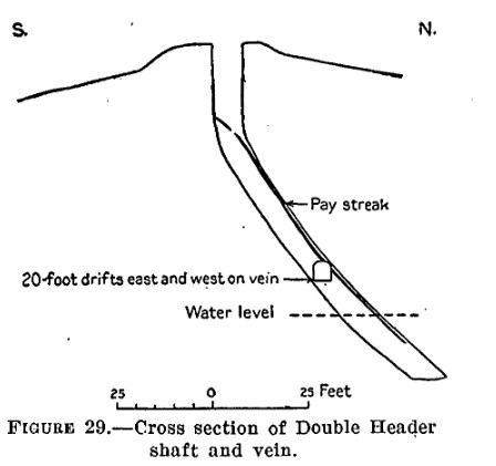
The Double Header prospect is one-eighth of a mile south of the Ultimo prospect, on open ground. It is developed by a 100 foot inclined shaft on an east-west vein in white silicified rock which seems to be rhyolitic tuff and is probably intrusive into the andesite. This rock contains a little disseminated pyrite, The dip of the vein flattens from about 60° near the surface to 30° in the lower part of the shaft.A thin black clayey gouge seperates the vein from the rock wall, especially on the hanging wallside. Water stands about 15 feet below the surface, The vein is composed mainly of the brecciated siliceous rock in which the ore occurs in lenses that are generally connected by seams of barite, The lenses contain mainly quartz, barite, galena, gray copper, and sphalerite. They are usually banded, with the sulfides mostly in the outer portion and the barite in the inner or middle portion. Quartz is sparingly present and is well crystallized in comb structure at right angles to the wall. On the dump is a small amount of ore which is said to run 47% in lead and $8 in gold and 44 ounces in silver to the ton. From some of this ore as high as $60 a ton was reported.
Alternate NamesNone CompanyJohn Parks, Anaconda-Arizona Mg. Co., Altamirano, Boulder Mg. Co.5 Mining DistrictWrightson District Location21S 15E, NW¼ Cen. S., Cen. & SW¼ 3 N. Cen. & NE¼ 105 Mineral ProductsAg, Pb, Cu, Zn-, Au- 5 GeologyLensing quartz fissure veins containing calcite and barite, and with shoots, stringers, and seams of argentiferous galena, chalcopyrite, sphalerite, tetrahedrite and pyrite. Veins are often vuggy with mineralization banded or lining vugs. Wall rock is Triassic rhyolite and latite volcanics [Anaconda Group as a whole].5 Type of Operation and ProductionTunnel and shaft operations. Worked from early 1870s and intermittently through 1949, producing some 300 tons of ore averaging about 5% Pb, 30 oz. Ag/T, 3% Cu, and minor Au. [Anaconda Group as a whole]5 References
|