|
Note: in these deed histories distances are quoted in perches (p) of length 16.5 feet. Areas are quoted in acres (a) and square perches (p). There are 160 square perches to an acre. In a few cases roods (a quarter of an acre) are also used.
|
|
|
Branch A |
From |
To |
Date |
Area |
Cost |
Reference |
|
|
|
|
|
|
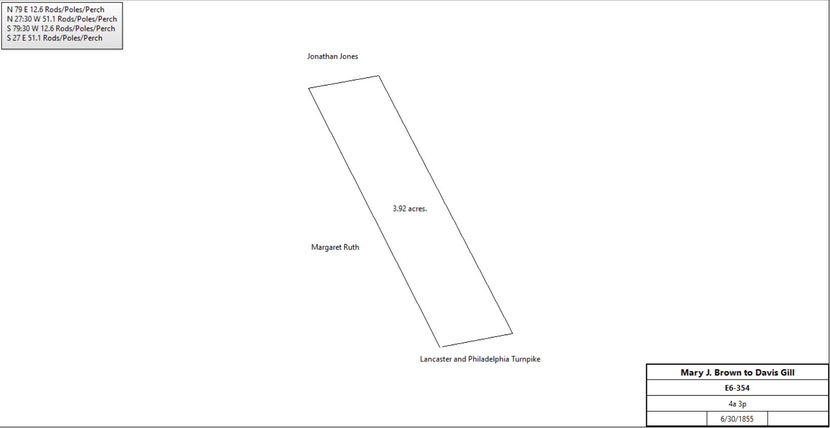
Mary J. Brown |
Davis Gill |
6/30/1855 |
4a 3p |
$1,000 |
E6-354 |
|
Branch B |
From |
To |
Date |
Area |
Cost |
Reference |
|
|
|
|
|
|
|
|
|
|
|
C4-215 |
Hannah Chandler |
Philip Thomas |
4/6/1830 |
9.25a |
$1,099 |
D4-11 |
Philip & Frances Thomas |
John Hutchison |
2/1/1833 |
9.25a |
$1,400 |
F4-326 |
John & Mary Hutchison |
Davis Gill |
2/15/1849 |
9.25a |
$2,200 |
I5-100 |
Branch C |
From |
To |
Date |
Area |
Cost |
Reference |
|
|
|
|
|
|
Christian & Magdalen Zook |
John Showalter, father of David Showalter |
3/14/1793 |
6a 35.8p |
$1,943 |
X5-478 |
John Showalter, administrator of the estate of David Showalter |
Edward Schofield |
2/12/1844 |
12a 70p |
$460 18c |
Z4-419 |
Edward & Susanna Schofield |
U. V. Pennypacker |
2/12/1844 |
12a 70p |
$460 18c |
Z4-418 |
U. V. & Mary Pennypacker |
Davis Gill |
3/28/1844 |
2a 6p |
$64 |
Z4-420 |
Branch D |
From |
To |
Date |
Area |
Cost |
Reference |
|
|
|
|
|
|
John G. Bull & Joseph Rowland |
John Thomas |
8/27/1816 |
|
|
J3 (67)-373 |
Jonathan Thomas et al, heirs of John Thomas |
Henry Harnish |
3/31/1871 |
20a |
$4,000 |
A8-29; buildings |
Henry Harnish |
Pennsylvania Railroad |
~1877 |
0.852a |
|
deed not found |
Henry & Emma Harnish |
George Bloomer |
4/2/1880 |
20a |
$4,500 |
C8-138; messuage |
George & Charlotte Bloomer |
R. G. Stotesbury |
11/20/1880 |
20a |
$5,500 |
J9-60; messuage |
Branch E |
From |
To |
Date |
Area |
Cost |
Reference |
|
|
|
|
|
|
John Parker |
Charles McKeeman |
3/10/1797 |
|
|
Q2(40)-371 |
Isaac Jones |
Charles McKeeman |
8/5/1801 |
|
|
V2(44)-321 |
Charles McKeeman |
John G. Bull & Joseph Rowland |
3/27/1815 |
30a |
|
Q3-243 |
John G. Bull & Joseph Rowland |
William Odgen |
3/11/1817 |
8a 23p |
$1,222 50c |
U3-392; messuage |
E. & M.S. Ogden |
|
1883 |
20a |
|
Breou’s atlas |
Branch F - John McConnell |
From |
To |
Date |
Area |
Cost |
Reference |
|
|
|
|
|
|
Hiram Litzenberg |
Thomas Kenny |
4/2/1842 |
1a 7p + 2a 141p |
|
V4-513 |
Thomas Kenny |
James Kenny |
10/26/1844 |
1a 7p + 2a 141p |
$400 |
A5-438; messuage |
Brinton Darlington, Sheriff, debt of James Kenny |
David Christie |
11/1/1849 |
4a |
$411 |
Sheriff’s deed 5-346; neighbors Jonathan Jones, James & Sarah Ogden, et al |
David & Nancy Christie |
John McConnell |
10/26/1856 |
4a |
$1,150 |
A6-278: neighbors Jonathan Jones, James & Sarah Ogden, Howard Williams, et al |
John McConnell |
|
1873 |
|
|
Witmer’s atlas |
J. Connell |
|
1883 |
not quoted |
|
Breou’s atlas |
|