|
Note: in these deed histories distances are quoted in perches (p) of length 16.5 feet. Areas are quoted in acres (a) and square perches (p). There are 160 square perches to an acre. In a few cases roods (a quarter of an acre) are also used.
References:
Garry Wheeler Stone. "The Mount Joy Forge on Valley Creek." In The Scope of Historical Archaeology: Essays in Honor of John L. Cotter. Edited by David G. Orr and Daniel G. Crozier. Philadelphia: Temple University Department of Anthropology, 1984. Page 102.
Ann F. Rhoads, Douglas Ryan, and Elle W. Aderman, Land Use Study of Valley Forge National Historical Park, Contract #CA4000-7-8021, March 1989.
|
|
|
From |
To |
Date |
Area |
Cost |
Reference |
|
|
|
|
|
|
Warrant |
John Potts |
6/1/1758 |
110a |
£15 10s |
Stone; see deed plan in Rhoads |
William Dewees |
Isaac Potts |
1784 |
|
|
Mont. 3-415 |
Joseph Potts |
|
1798 |
|
|
Not in Glass Tax returns |
Joseph Potts & Sarah, his wife |
Ralph Peacock |
7/12/1806 |
811¾a and 133a 82p |
$12,500 |
Mont. 23-11 C3-133a |
Ralph Peacock |
George Suckley |
|
Forge, slitting mills & tracts |
$6970 |
C3-138 |
George Suckley & wife |
Rebecca Robins |
2/25/1808 |
Forge, slitting mills & tracts |
$22,000 |
C3-139a
Mont. 25-125 |
Rebecca Robins |
Jacob Vodges |
3/11/1814 |
|
|
Mont. 30-150 |
|
|
|
|
|
Property split |
Jacob Vodges & Mary, his wife |
John Rogers & Joshua Malin |
3/11/1814 |
113a 104p
Forge, slitting mills & tracts |
|
Mont. 30-587 |
Charles & Rebecca Rogers, administrators of the estate of John Rogers of Sadsbury |
Joshua Zimmerman |
1/7/1841 |
5a 35p + 27.25a (Tredyffrin) + 7a 18p (Schuylkill) + 12a 50p (Charlestown, sic) |
$2,205 48c |
C5-490 |
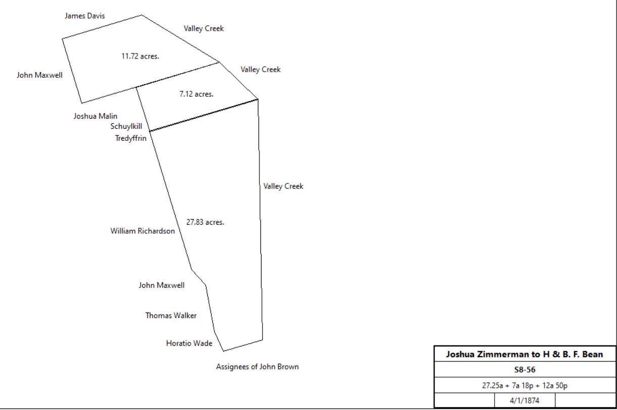
Joshua & Margetta Zimmerman |
H. & B. F. Bean |
4/1/1874 |
5a 35p + 27.25a + 7a 18p + 12a 50p |
$4,000 |
S8-56 |
|
James McFarland, sheriff, debt of Henry and B. F. Bean |
George W. Bean |
3/29/1880 |
Tredyffrin: #1 5a 35p, #2 7a 40p, #3 7a 18p, #4 12a 55p;
Schuylkill: #5 5a, #6 129p, #7 67p, #8 3a 109p, #9 4a, #10 5a, #11 2.5a, #12 120p, #13 0.5a, #15 5a 152p (half interest);
Charlestown #14 20a 74p |
$690 |
G9-552 |
George W. Bean |
|
1883 |
Not quoted |
|
Breou’s Atlas |
George W. & Annie Bean |
Benjamin F. Fisher |
6/19/1901 |
7a 109.75p |
$192 15c |
E11-451, part of lot #4 |
|
|
C3-133 Joseph Potts and wife to Ralph Peacock
Whereas Mary Potts and the said Joseph Potts and his wife by Indenture quinquepartite bearing date 12/25/1805 did grant and convey unto Samuel Hockley of Douglas township aforesaid iron master in fee All those messuages Forge and Slitting Mills known by the name of The Valley Forge and all and singular the lands tenements and hereditaments thereunto belonging situate and lying and being partly in upper merion township in the County of Montgomery and partly in Charlestown township in the County of Chester and State aforesaid …
Beginning at a sugar tree standing by the side of Valley Creek below the Forge and Slitting Mill Dam and running thence N58ºE 16 perches to a post, thence N7ºE 20.6 perches to a post, thence S83ºE 14 perches to a post, thence S7ºW 22 perches to the great road leading to Philadelphia, thence by the same S83ºE 96 perches to a post, and S53ºE 60 perches to a post on the westerly side of said road, thence by land of Davis Stephens S12½ºW 68 perches to a Black Oak & stump, and S27½ºE 112 perches to a post on the corner of John Brown’s land, thence partly by the said Brown’s land and partly by lands late of William Curry S63½ºW 124 perches to valley creek and 102 perches beyond the Creek to a stone, a corner of Curry’s land, thence by the same N24ºW 155 perches to another stone corner of the same, then by a long line called Bilton’s or Welsh line S74ºW 366 perches to a stone, thence by lands of John Lloyd N7½ºW 56 perches to a chestnut oak, thence N16½ºE 132 perches to a stone, thence S55½ºE 4.3 perches to a stone, thence N32½ºE 118 perches, and N55½ºW 24 perches to a birch, and N32½ºE 24 perches to a white oak, thence by lands of John Boyer S55½ºE 85 perches, and N8ºW 85 perches to a black oak …
|
|
Table T.1 Plot #4
|
From |
To |
Date |
Area |
Cost |
Reference |
|
|
|
|
|
|
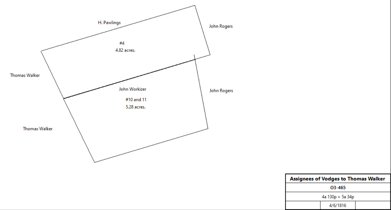
Smith et al (Jacob Vodges) |
T. Walker |
4/6/1816 |
#4: 4a 130p
#10 & 11: 5a 34p |
$1460.40 |
O3-465 (also plot #10 & 11) |
|
Thomas Walker |
Richard C. Walker |
9/21/1835 (will) |
5a 84p |
|
|
Havard Walker & Elijah Pennypacker, executors of the will of Richard C. Walker |
Matthias P. Walker |
4/2/1873 |
5a 84p |
$585 |
M8-318; description same as tracts #10 & 11 |
Estate of Matthias P. Walker |
Mary Corona Machemer |
|
1/2 of 5a 84p |
|
O37-565; Will of Matthias P. Walker |
The Continental Bank et al, executors of the wills of Nathan R. Walker, Mary Corona Machemer, Mary McF. Cutler, and Emma McFarland Platt |
USA |
6/7/1978 |
5.52a |
$10,500 |
Z53-463; Tract 101-15. Deed 5538616 |
|
|
|
|
|
|
|
|
|
|
|
|
|
|
|
|
|
|
|
|
|
|
|
|
|
|
Table T.2 Plot #5
|
From |
To |
Date |
Area |
Cost |
Reference |
|
|
|
|
|
|
Smith et al (Jacob Vodges) |
John Workizer |
8/28/1816 |
3a 70p (Tredyffrin) &
2a (Charlestown) |
$774 |
O3-254 |
John Workizer |
Henry Heebner |
1/15/1820 |
3a 70p |
$618.75 |
S3-390 No sale by Heebner in index. Montgomery county? |
|
|
O3-254 Tract #2 – beginning at a corner of John Shannon, line of James Davis, thence by same N17°W 5½ to a stake, thence S8½°W 35.1 to a stone, thence by Abraham Krupp S11¾°W 11.4 to another corner of John Shannon, thence by same N73°E 41 to the place of beginning.
|
Table T.3 Plot #6
|
From |
To |
Date |
Area |
Cost |
Reference |
|
|
|
|
|
|
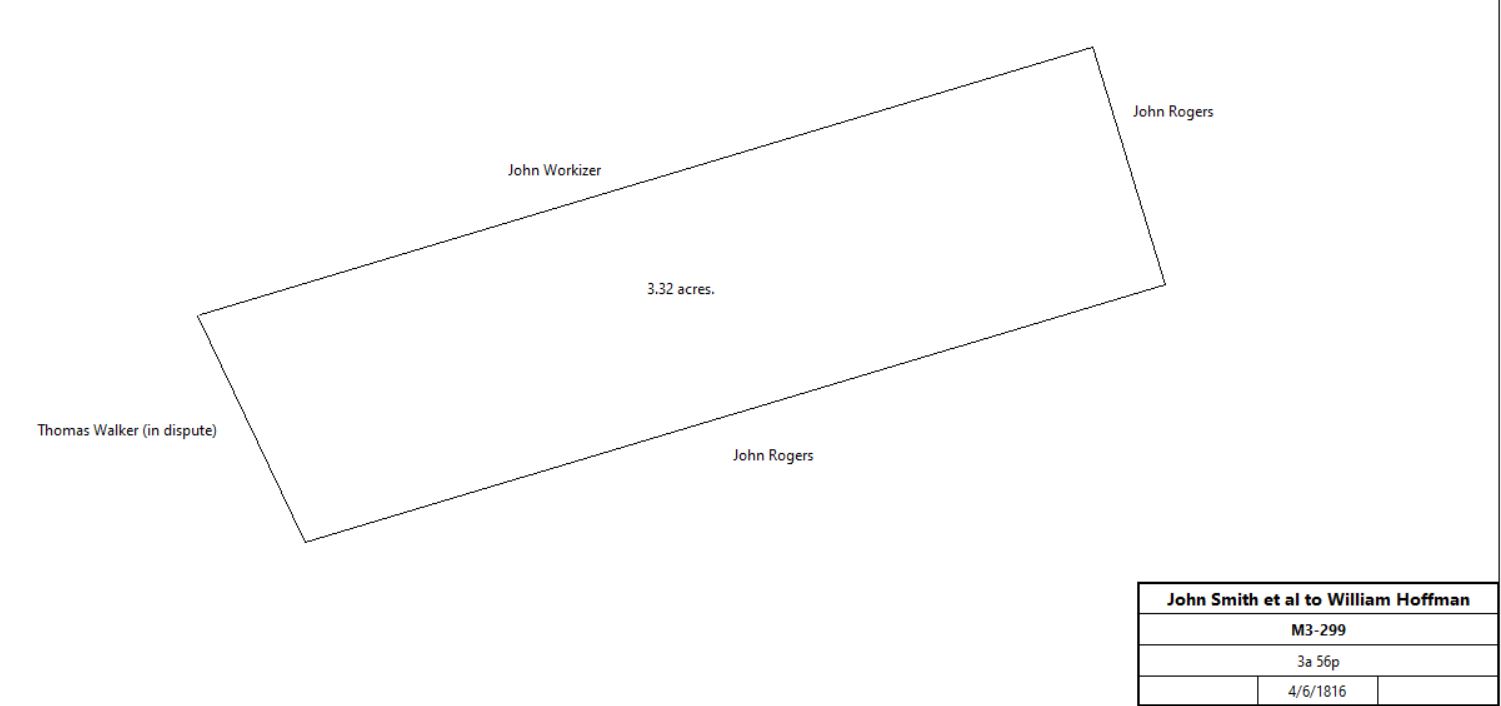
Smith et al (Jacob Vodges) |
William Hoffman aka Haffman |
4/6/1816 |
3a 56p |
$619.44 |
M3-299 |
|
William Hoffman |
William McGlathery |
|
|
|
No sale deed found |
William McGlathery |
|
7/25/1850 (will) |
|
|
died |
Mehelm McGlathery, executor of the will of William McGatherly |
Abraham Bond & James Scully |
12/13/1851 |
3a 50p |
$110 |
Y6-207 |
Mehelm McGlathery, executor of the will of William McGatherly |
Abraham Bond & James Scully |
12/13/1851 |
3a 70p |
$111 |
W6-522 |
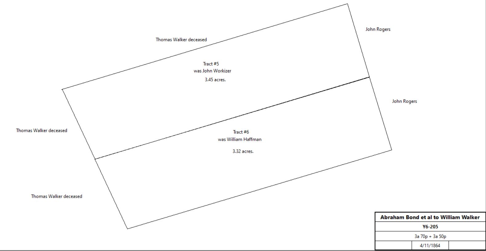
Abraham Bond & James Scully |
William Walker jr. |
4/11/1864 |
3a 70p + 3a 50p |
$150 |
Y6-205 |
|
Zilla Walker |
Mary (nee Walker) & Howard Hoy |
12/28/1950 |
2 tracts |
$1 |
K23-298 |
Zilla Walker and Mary & Howard Hoy |
David Stout |
1/8/1952 |
|
|
deed of confirmation |
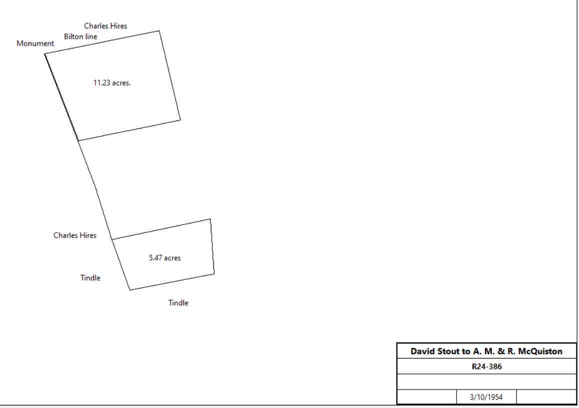
David Stout |
A. M. & Ruth McQuiston |
3/10/1954 |
2 tracts |
$800 |
R24-386 |
|
|
|
|
|
|
No other McQuiston deeds found in this area. |
|
|
Table T.4 Plot #7
|
From |
To |
Date |
Area |
Cost |
Reference |
|
|
|
|
|
|
|
John Rogers |
|
|
|
No deed found |
|
|
Table T.4 Plot #8
|
From |
To |
Date |
Area |
Cost |
Reference |
|
|
|
|
|
|
Smith et al (Jacob Vodges) |
William Richardson |
4/26/1816 |
2a 156p |
$297.50 |
M3-389 |
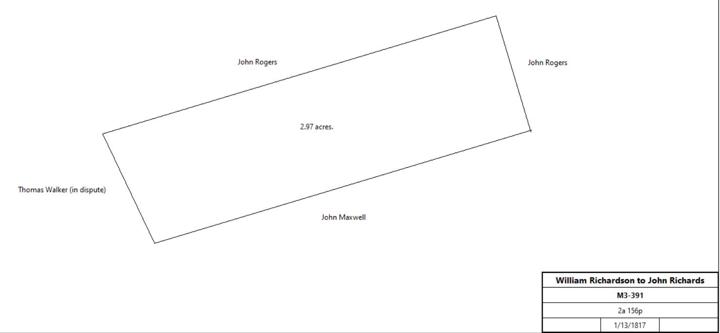
William Richardson |
John Richards |
1/30/1817 |
2a 156p |
$416.16 |
M3-391 |
|
Isaac Richards et al, the 6 children of John Richards and their heirs |
Joseph B. Walker |
4/14/1855 |
2a 156p |
$130 |
B6-30 |
Will of E. Virginia Walker |
Commonwealth of Pennsylvania |
8/6/1968 |
2a 156p |
$300 |
H38-886 |
|
Table T.5 Plot #9
|
From |
To |
Date |
Area |
Cost |
Reference |
|
|
|
|
|
|
Smith et al (Jacob Vodges) |
Peter Wagonseller |
4/11/1817 |
2a 53p + 2a 47p |
$1160 98c |
Q3-27 (also plot #12) |
.jpg)
|
Matthias P. Walker |
|
1950 |
6.93a |
|
Atlas |
|
|
Table T.6 Plot #12
|
From |
To |
Date |
Area |
Cost |
Reference |
|
|
|
|
|
|
Smith et al (Jacob Vodges) |
Peter Wagonseller |
4/11/1817 |
2a 53p + 2a 47p |
$1160 98c |
Q3-27 (also plot #9) |
Peter Wagonseller & wife |
Henry Rhoades |
4/20/1820 |
|
|
not found |
Henry Rhoades |
|
8/6/1821 |
|
|
will |
Catharine & Henry Rhoads, and Moses Robinson, execs of Henry Rhoades |
James Wood & John Morgan |
4/1/1826 |
2a 47p |
$61 17c |
Z3-317 |
James Wood |
John Morgan |
4/3/1826 |
|
|
not found |
James Wood |
Wife and 8 children |
1/1/1846 |
|
|
died intestate |
John & Anna Maria Morgan |
David Zook |
11/20/1860 |
½ part of 2a 47p |
$50 |
Z10-187? |
David Zook |
Eleanor Zook |
11/2/1863 |
|
|
Mont. Will 11-125 |
Deborah A. Wood |
Eleanor S. Zook |
3/19/1867 |
½ part of 2a 47p |
|
G27-691 |
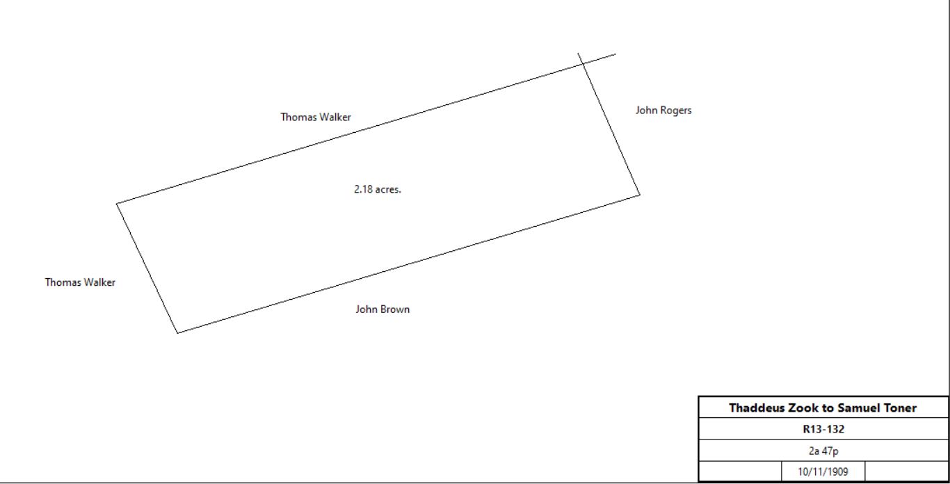
Thaddeus Zook (ex of Eleanor Zook) |
Samuel Toner |
10/11/1909 |
½ part of 2a 47p |
$75 |
R13-213 |
|
Samuel W. Toner |
Mary A. Toner, wife, and Mae I. & Samuel W. Toner, children |
2/27/1927 |
|
|
died intestate |
Mary A. Toner |
Mae I. & Samuel W. Toner |
6/25/1955 |
|
|
died intestate |
Samuel W. Toner |
Mae I. Toner |
7/16/1959 |
|
|
G31-579 |
Mae I. & Samuel W. Toner |
|
7/26/1959 |
|
|
Action to quiet title against Eleanor S. Zook |
Mae I. Toner |
Samuel W. Toner |
7/20/1961 |
|
|
died |
Samuel W. & Ann Toner |
A. M. & Ruth McQuiston |
11/16/1964 |
|
$800 |
C36-220; same description as R13-132 |
Ruth McQuiston |
USA |
4/8/1980 |
|
|
Miscellaneous 5580509; 474-434 |
|
|
2022 |
2.2a |
|
GIS database tax parcel 43-5-8.1 |
|
|
Table T.7 Plot #13 & Maxwell’s Quarters
|
From |
To |
Date |
Area |
Cost |
Reference |
|
|
|
|
|
|
Smith et al (Jacob Vodges) |
John Brown |
4/26/1816 |
8a 60p |
$1,122 25c |
C6-110 |
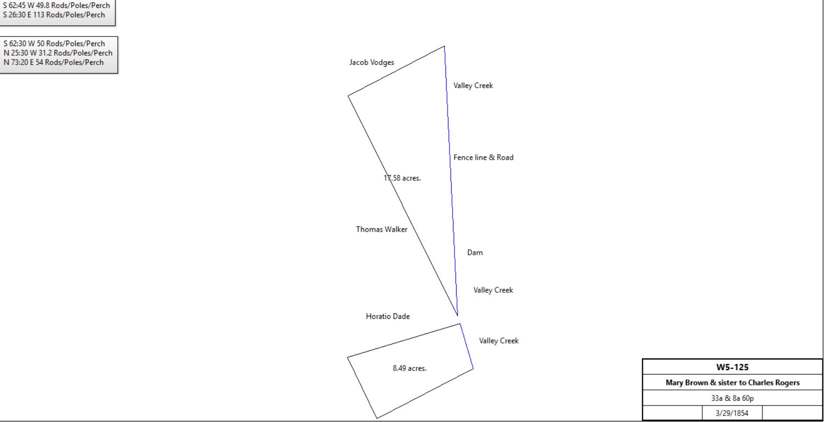
Samuel & Elizabeth Beaver & Mary A. Brown |
Charles H. Rogers |
3/29/1854 |
33a + 8a 60p |
|
W5-129 |
|
See table H |
|
|
|
|
|
|
|
Modern tracts
|
From |
To |
Date |
Area |
Cost |
Reference |
|
|
|
|
|
|
James McFarland, sheriff, debt of Henry and B. F. Bean |
George W. Bean |
3/29/1880 |
Tredyffrin: #1 5a 35p, #2 7a 40p, #3 7a 18p, #4 12a 55p;
Schuylkill: #5 5a, #6 129p, #7 67p, #8 3a 109p, #9 4a, #10 5a, #11 2.5a, #12 120p, #13 0.5a, #15 5a 152p (half interest);
Charlestown #14 20a 74p |
$690 |
G9-552 |

Breou's 1883 atlas
|
|
|
|
|
|
|
M. P. Walker |
|
1910 |
|
|
died |
|
|
|
|
|
|
M. P. Walker estate |
|
1933 |
6.93a |
|
|
|
|
1933 |
2.2a |
|
See T.6 Plot #12 |
Tindle tract |
|
1933 |
|
|
|
Matthias P. Walker |
|
1933 |
13.22a |
|
1950 atlas |
M. P. Walker estate |
|
1950 |
6.93a |
|
|
|
|
1950 |
2.2a |
|
See T.6 Plot #12 |
Tindle tract |
|
1950 |
|
|
|
Matthias P. Walker |
|
1950 |
13.22a |
|
1950 atlas |
PA |
USA |
4/28/1982 |
|
|
V59-484 |
|
|
|
75.8a |
|
43-5-9; Chester County GIS |
|


.jpg)


